^Isogonic lines
^Isogonic lines
Lines joining the places of equal declination (θ).
^Isogonic lines
Lines joining the places of equal declination (θ).
^Magnetic maps
The three magnetic elements are calculated at different places all over the globe & the results obtained are represented on geographical maps. Usually lines are drawn joining all places having same value of a magnetic element. Such maps are called magnetic maps. The commonly used lines on the magnetic maps are:
Dip & latitude
Assuming that terrestrial magnetism is due to a short magnet at the centre of the earth, then at any point on the surface, tan δ = 2 tan λ where δ is dip and λ is the magnetic latitude.

^Apparent dip
Let ![]() respectively be the vertical component, horizontal component & dip angle in a vertical plane inclined at some angle say α to magnetic meridian, then
respectively be the vertical component, horizontal component & dip angle in a vertical plane inclined at some angle say α to magnetic meridian, then ![]() .
.
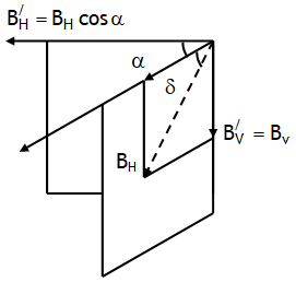
On dividing we wet tanδ/ = tanδ secα
From above relation we can write
In a similar way it can be proved that if δ1 and δ2 be the angles of dip observed in two vertical planes at right angles to each other and δ is the true angle of dip, then cot2 δ1 + cot2 δ2 = cot2 δ.
^Dip circle
Dip circle also called dip needle is a compass pivoted to move about a horizontal axis in a vertical plane containing the magnetic field of the earth i.e. it shows the angle which the magnetic field makes with the vertical. At the magnetic poles such a needle will point straight down.
A compass needle would stay along the magnetic meridian of the place. In some places on the earth there are deposits of magnetic minerals which cause the compass needle to deviate from the magnetic meridian. Knowing the magnetic declination at a place allows us to correct the compass to determine the direction of true north.
^Compass & dip circle
A compass needle consists of a magnetic needle is free to swing (oscillate or deflect) in a horizontal plane about a vertical axis.

A compass needle when placed in a horizontal plane & free to move aligns itself parallel to BH.
At the poles, the magnetic field lines are vertically so that the horizontal component is negligible & the compass needle can point along any direction & thus can’t be used as a direction finder. In that case we use a dip circle.
^Dip (δ) & Horizontal component
The vertical component of the Earth’s magnetic field points downwards in the northern hemisphere. If the magnetic needle of a dip circle is perfectly balanced about a horizontal axis so that it dips (moves down) in a vertical plane of the magnetic meridian and aligns. Itself at some angle to horizontal at which ![]() are parallel, this angle is known as the angle of dip (also known as inclination).
are parallel, this angle is known as the angle of dip (also known as inclination).
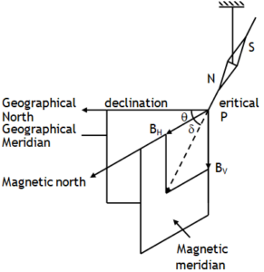
We can say that angle of dip at a place in the magnetic meridian is the angle between horizontal component of earth’s magnetic field (H) & its resultant intensity (B) or it is the angle made by the axis of a freely suspended magnet with the horizontal line. e.g. Dip angle = 420 at Delhi.
In figure shown, the resultant magnetic field is in the magnetic meridian, d is angle of dip, BH and BV denote horizontal and vertical components of Earth’s magnetic field respectively.
BH = B cosδ, BV = Bsinδ
![]()
Exactly at the equator the Earth’s magnetic field is parallel to the Earth’s surface, angle of dip & vertical component of Earth’s magnetic field are zero, thus a freely suspended magnet will be horizontal at the equator. Exactly at the centre of poles the Earth’s magnetic field is normal to the surface of the Earth, angle of dip is 900 and the horizontal component of the Earth’s magnetic field is zero. Therefore a freely suspended magnet will become vertical at the poles.
Declination (θ)
Since the line joining the magnetic poles is titled with respect to the geographic axis of the earth, the magnetic meridian at a point makes angle with the geographic meridian. This angle between the true geographic north and the north shown by a compass needle at which the needle stays in equilibrium in magnetic meridian is called the mag. declination or simply declination.
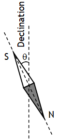
The declination is greater at higher latitudes and smaller near the equator. The declination in India is small, it being 0º41′ E at Delhi and 0º58′ W at Mumbai. This means a compass needle would deflect towards east by 0 degrees & 41 minute at Delhi & towards west by 0 degrees & 58 minute at Mumbai. As both angles are almost 00, Thus, we can say, at both these places a magnetic needle shows the true north quite accurately.
^Magnetic meridian
Magnetic meridian at a place is a vertical plane passing through the imaginary line joining the earth’s magnetic north and the south poles or the axis of a freely suspended magnet with its north pole towards geographic north.
^Geographic meridian
Geographic meridian at a point P on earth’s surface is a vertical plane passing through the longitude circle & axis of rotation of the earth.